History-Collectors.com
1943 British 21 Army Group Military Road Map - First Edition Sheet 7 - Basel–Stuttgart Southwestern Germany - Alsace France - Northern Switzerland - Ready For Framing
1943 British 21 Army Group Military Road Map - First Edition Sheet 7 - Basel–Stuttgart Southwestern Germany - Alsace France - Northern Switzerland - Ready For Framing
Couldn't load pickup availability
Vintage Original 1943 British 21 Army Group Military Road Map - First Edition Sheet 7 - Basel–Stuttgart Southwestern Germany - Alsace France - Northern Switzerland - Ready For Framing
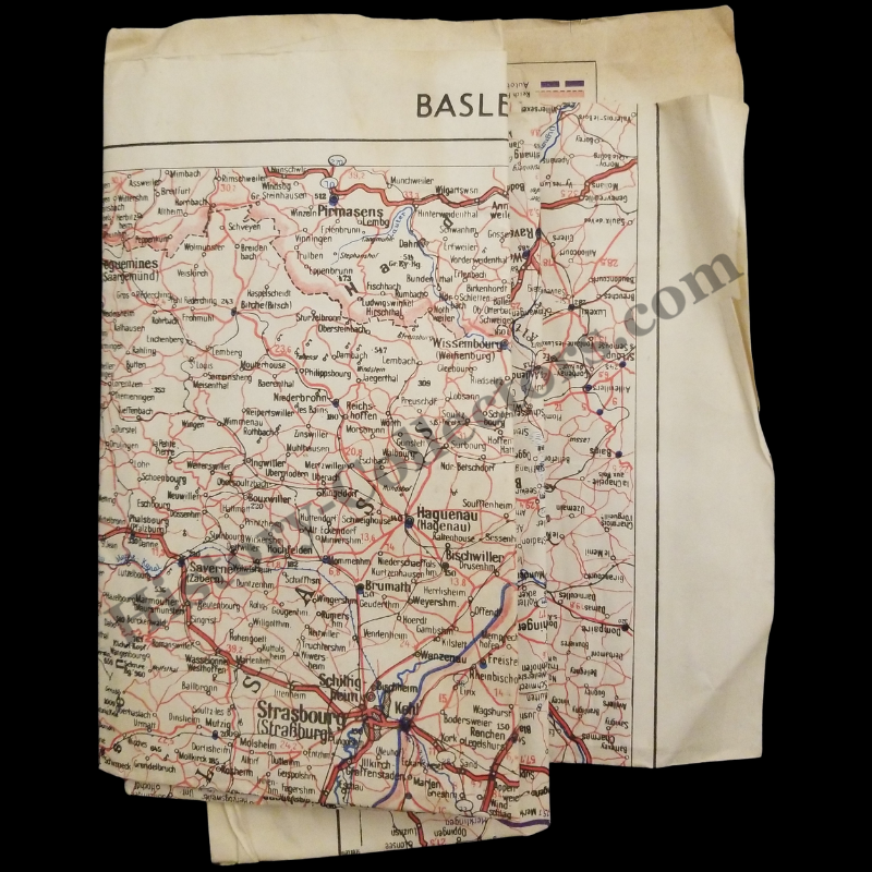
Second World War military road map produced in 1943 by 21 Army Group, covering the Basel–Stuttgart corridor of southwestern Germany, eastern France (Alsace), and northern Switzerland. Issued at a scale of 1:500,000, this map was created for operational planning and field use by British-led Allied forces during the buildup to the advance into northwest and central Europe.
The map emphasizes primary and secondary road systems in red, with railways, rivers, towns, and regional boundaries clearly shown. The level of road detail reflects its purpose for vehicle movement, logistics, and staff-level route planning, rather than civilian navigation. Terrain and waterways are included to support transport and engineering decisions.
The coverage area focuses on key transport routes leading toward southern Germany, with Basel serving as a major geographic reference point near the Rhine. Although Switzerland remained neutral, its border cities and infrastructure were essential reference features in Allied military cartography.
Details:
Date: 1943
Issuing authority: 21 Army Group
Type: Military Road Map
Scale: 1:500,000
Coverage: Southwestern Germany, Alsace (France), Northern Switzerland
Edition: First Edition, Sheet 7
An authentic example of British Army operational cartography from the Second World War, well suited for collectors of WWII militaria, historians of Allied planning, and enthusiasts of historical ephemera.
In Good Vintage Condition - Creases / Folds, Edge Wear With Tears, Paper Brittling, Paper Toning Due To Age And History-Collectors Watermarked That Is Not On The Map. Unfolded Measures Approx. 25-1/4" Wide by 31-1/2" Tall. Will Be Shipped Folded.
Product Photos Include A Watermark And Possibly An Object For Scale / Photography Purposes Only. Also, Product Listings May Include Newspaper Images, Display Photos Or Short Video Clips Relevant To The Item Which Are Not Included In The Purchase. The Product Title Is For The Exact Item Available.
Share